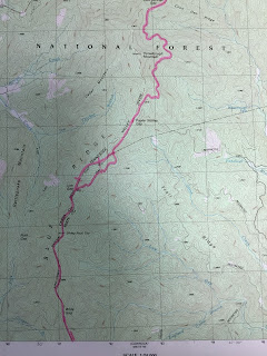
The walk in was not bad some uphill sections initially then the trail leveled and ran along a ridge-line. That first campsite was really nice grassed in and a great view to boot.
We awoke the next day and started to break camp and cook some breakfast ( Oatmeal and coffee ) as some early birds passed the campsite. Readying ourselves we set out on our first day with a goal of a little over 20 miles and to end the day at the cheese factory site. Dropping into Stewart Branch Spring we filled our water situation. Setting off again we dropped into Tesnatee Gap where we shed some clothes for the upcoming heat of the day. Up and over and down into Hogpen Gap we are followed by some hikers, one of whom I nicknamed Gandalf because of the wooden staff he was using. We had passed wildcat Mountain and the Whitley Gap Trail which lead to the Whitley Gap Shelter and a fresh water spring. I believe at Hogpen Gap we saw four ladies hiking that looked liked they where being resupplied. Items all laid out to be packed away. Up and over Wolfpen Stamp and onward to Strawberry Top down into Sapling Gap and over to Poor Mountain. Here we enter the next map.
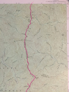
Hiking along a ridge-line we passed numerous spots with names such as Wide Gap, Sheep Rock Top, Low Gap and Poplar Stomp Gap.
Passing Horsetrough Mountain we worked our way over to Chattahoochie Gap and in a few miles we would go over our first 4000 ft mountain ( Blue Mtn).
After Blue Mtn we dropped into Unicoi Gap I checked my foot for a possible hot-spot readied for some more miles to the Cheese Factory Site. Crossing over Indian Grave Gap we had a mile to go to the Cheese Factory ( little triangle above the D in Blue "Ridge" ). Here we stopped at another great little camp site I was so tired here that I set up my tent and bid Evan Adieu without eating. We awoke refreshed and a little sore but ready to go and rendezvous with Courtney and Olline. Breakfast fixed and coffee drank we readied for our next major mountain ( Tray Mtn ) the highest summit of this journey. The top of Tray was covered with Rhododendrons with the exception of a small area of bare rock. Coming off Tray mountain headed downward past the shelter. Through Wolfpen and Steeltrap gaps we pressed on toward Sassafras gap.
We passed Young Lick and continued onward toward the Swag of the Blueridge. It is a fairly level section of the trail covering some 4 or 5 miles. Over Round Top and down into Sassafras Gap. We stopped here and Evan took off and obtained water for the both of us. I slipped out of my backpack and took up residence at the base of a large oak tree. Stopping after a strenuous hike is a cooling afair, I covered up in my rain poncho ate a snack and awaited Evans return. We picked up some stray trash ( actually a small hip flask that smelled of Bourbon ) and headed toward our rendezvous with the ladies. Over and down into Addis Gap and upward to Kelly Knob ( 4130 ft ) the fourth of the 4000 ft mountains of the hike. This was quite possibly toughest section the AT so far. Dropping down into Deep Gap we met up with the ladies getting back into gear after a short chat we headed up to Wolfstake Knob and Powell Mtn the end was beginning to close in on us.
As you can see by this last map Dicks Creek Gap was close at hand. A group of hikers had gathered at the picnic spot located at the parking area. We hopped into Courtney's truck and headed home via a good burger joint. The next section is quite long at 40 miles and will probably take 3 days to complete. Dicks Creek Gap over to Franklin in North Carolina. Look forward to hearing your comments on the blog so far. John...


